Turkey : Webmaster's Map
"Webmaster's Maps" are outline maps with coordinates for imagemap. They help you to publish web contents about Turkey.
Feature & How to use
- How to Save Maps ?
- Hold down the right button of your mouse on graphics and select "Save As".
- Divided into Provinces
- Turkish territory is divided into provinces. So you can easily color each provinces.
- Drawing
- The Anatolia - so called Asia Minor - is little bit thicker than reality. You can write in maps easily.
- Islands are omitted except for Turkish territory. Because maps are so complicated if all of them are shown.
- Sample of Use
- Links to Turkish Web Sites: Regional Section.
- Turkey in Pics: Texts are in Japanese.
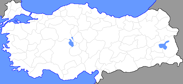
630 pixels width x 292 pixels height
Convenient in most cases. This one easily placed in 760 pixels width web pages.
630 x 292 Basic Image
- File Name: 630type1.png
- Turkish Territory - White (#ffffff)
- Water Surface - Light Blue (#6699ff)
- Provincial Borders - Light Grey (#cccccc)
- Foreign Territories - Grey (#999999)
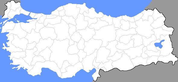
630 x 292 with International Borders
International land borders are drawn. Borders between other countries are not drawn.
- File Name: 630type2.png
- Turkish Territory - White (#ffffff)
- Water Surface - Light Blue (#6699ff)
- Provincial Borders - Light Grey (#cccccc)
- International Borders - Black (#000000)
- Foreign Territories - Grey (#999999)
630 x 292 with International Borders and Coastlines
Coastlines are added to above.
- File Name: 630type3.png
- Turkish Territory - White (#ffffff)
- Water Surface - Light Blue (#6699ff)
- Coastlines - Blue (#0000ff)
- Provincial Borders - Light Grey (#cccccc)
- International Borders - Black (#000000)
- Foreign Territories - Grey (#999999)
Coordinates for Imagemap
Please change the value of links & alternative texts.
- 630coordu.txt: (UTF-8N)
- Alternative texts are written in Turkish. So Turkish fonts are required.
- 630coordi.txt: (ISO-8859-1)
- Turkish fonts are replaced with similar fonts.
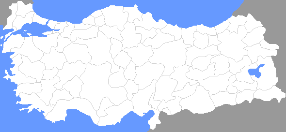
590 pixels width x 273 pixels height
Somewhat smaller than 630 x 292. So visiters can open several windows at once. These maps are adequate for pages like reference links.
590 x 273 Basic Image
- File Name: 590type1.png
- Turkish Territory - White (#ffffff)
- Water Surface - Light Blue (#6699ff)
- Provincial Borders - Light Grey (#cccccc)
- Foreign Territories - Grey (#999999)
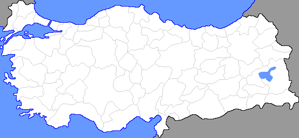
590 x 273 with International Borders
International land borders are drawn. Borders between other countries are not drawn.
- File Name: 590type2.png
- Turkish Territory - White (#ffffff)
- Water Surface - Light Blue (#6699ff)
- Provincial Borders - Light Grey (#cccccc)
- International Borders - Black (#000000)
- Foreign Territories - Grey (#999999)
590 x 273 with International Borders and Coastlines
Coastlines are added to above.
- File Name: 590type3.png
- Turkish Territory - White (#ffffff)
- Water Surface - Light Blue (#6699ff)
- Coastlines - Blue (#0000ff)
- Provincial Borders - Light Grey (#cccccc)
- International Borders - Black (#000000)
- Foreign Territories - Grey (#999999)
Coordinates for Imagemap
Please change the value of links & alternative texts.
- 590coordu.txt: (UTF-8N)
- Alternative texts are written in Turkish. So Turkish fonts are required.
- 590coordi.txt: (ISO-8859-1)
- Turkish fonts are replaced with similar fonts.
Terms of Use
These files are offered as linkware. You are required to create a link to this website.
- Examples of HTML code
- <a href="http://turkey.areastudy.net/imagemap.html">Turkey: Webmaster's Map</a>
- <a href="http://turkey.areastudy.net/">http://turkey.areastudy.net/</a>
- <a href="http://www.areastudy.net/">areastudy.net</a>
It is not always necessary to creat links on same page where graphics are used. You may create links on any page of your website (e.g. in reference links). But the page must be open to the public.
Do not redistribute these files. Only for use in your own website.